Search Term Record
Metadata
Name |
Winsted, Minnesota maps |
Related Records
-
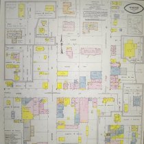
Map - Winsted, Minnesota 1923 fire
Copy of the December 1923 map of Winsted, McLeod County, Minnesota. Surveyed by General Inspection Bureau, Walter I. Fisher, Mgr. Map was used for insurance purposes. Population: 500; Prevailing winds: NW. Fire protection, waterworks and fire department equipment & alarm are described. Buildings are named, street addresses are marked, windows and number of stories are indicated, & stucco is noted. Map key. The original map is at City Hall, ...
Record Type: Archive
-
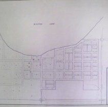
Map - Winsted, MN
Map of Winsted, MN created by M.W.P.A. Project 5259, c.1935-1943. Shows blocks, lots, streets, Minnesota Western Railroad tracks, location of public buildings, section corners, & Winsted Lake.
Record Type: Archive
-
Map - Winsted, MN 1958
September 1958 map of Winsted, McLeod County, Minnesota. Surveyed by Fire Underwriters Inspection Bureau, Minneapolis. It was used for insurance purposes. Population:1200; Prevailing winds: NW. Fire protection waterworks and fire department equipment & alarm are described. Fire ordinances were rated fair, regulations inadequate. Buildings are color coded for construction materials.
Record Type: Archive