Search Term Record
Metadata
Name |
Stewart, Minnesota maps |
Related Records
-
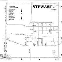
Map - Stewart, Minnesota
Map of Stewart, Minnesota with named streets & index. Shows Hwy 212 and Twin Cities & Western Railroad. Undated
Record Type: Archive
-
Map - Stewart, Minnesota
Map of Stewart, MN created by M.W.P.A. Project 2309, c.1935-1943. Shows blocks, lots, streets, Chicago, Milwaukee, St. Paul Pacific Railroad tracks, location of public buildings, section corners and section center. Markings show South Street updated to TH 212 (212-12-F) with Highway Department reference number 4309.
Record Type: Archive
-
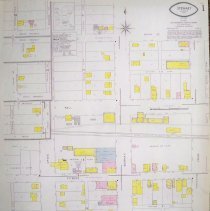
Map - Stewart, MN 1959
July, 1959 map of Stewart, McLeod County, Minnesota. Surveyed by Fire Underwriters Inspection Bureau, Minneapolis. It was used for insurance purposes. Population:700; Class 8. Fire protection waterworks and fire department equipment & alarm are described. Fire ordinances were rated inadequate. Buildings are color coded for construction materials.
Record Type: Archive