Search Term Record
Metadata
Name |
Maps |
Related Records
-
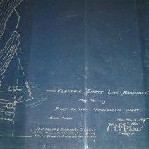
Blueprint - Electric Short Line Railway Co., Minneapolis West
Electric Short Line Railway Company map showing Right of Way from Minneapolis West, March 16, 1914. Signed by W. L. Luce, President. Sheet No.1 of 8 showing right of way from Minneapolis to a point 3 miles west of Hutchinson from Survey Station 72+63 to Survey Station 207+71. Encapsulated with Sheet No.2: 2003-0179-002.
Record Type: Archive
-
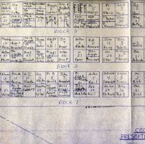
Map - 1869 map-Acoma Township-Lewis Harrington
1869 hand-drawn map of Acoma Township by Lewis Harrington. Numbered into sections and shows lakes and landowners.
Record Type: Archive
-
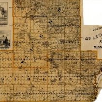
Map - 1874 McLeod & Sibley counties
Map of the counties of McLeod and Sibley, Minnesota. From the 1874 Andreas Atlas of Minnesota,
Record Type: Archive
-
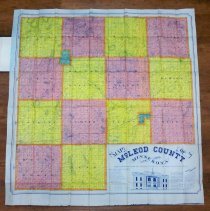
Map - 1910 McLeod County
Map of McLeod County, Minnesota, October, 1910. Compiled, drawn and printed by I. D. Barton, Publisher of County Maps, Sauk Center, Minn. Shows railroads, team roads, rivers, farmhouses, schools, churches, landowners. The pocket folding map has a stiff board cover like a book. The map could be obtained by mail order with personal delivery and no canvassers. County officers for 1911-12 are listed: Auditor, F. D. Stocking, Glencoe; Treasurer, ...
Record Type: Archive
-
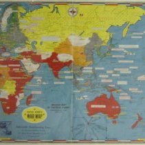
Map - 1914 European battlefield map
War map of the Battle Ground of Liberty - the Western Battle Fields of Europe. A Strategic Map of the Battle Ground in Belgium and France from London, England to the Swiss border. Showing the farthest advance of the German Armies, September, 1914. Divided into twelve mile squares with symbols for railways & stations, forts, wagon roads, and fortified places. Published by Rand McNally & Co.
Record Type: Archive
-
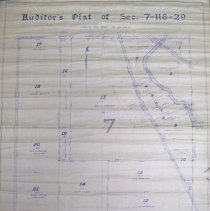
Map - 1926 Hassan Valley auditor's plat
1926 Auditor's plat map of Section 7, Township 116, Range 29 (Hassan Valley Township) by Carlisle Madson, McLeod County Surveyor. Approved by Board of County Commissioners in November, 1926. Signed by J. J. Leasman, County Auditor and William O. McNelly, County Attorney. Most of this property later became part of Hutchinson, Minnesota. A large portion belonged to Sam G. Anderson.
Record Type: Archive
-
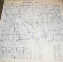
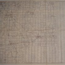
Map - 1940 plat of McLeod County
1940 plat map of McLeod County. Shows names of rural residents. Attached to wooden slats for hanging.
Record Type: Archive
-
Map - 1944 D-Day World War II
Dated Events War Map in color. Invasion map of Fortress Europe, commemorating D-Day, June 6, 1944. Significant World War II events are noted on information bars across the countries. Includes an inset map of the invasion of France and air distances to Berlin and to Tokyo. The legend shows naval bases, the Axis and its countries, countries conquered by the Axis, grey turns to red as U. S. & Britain smash Axis, and the neutral countries. Also ...
Record Type: Archive
-
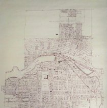
Map - 1959 Hutchinson, MN
1959 map of the City of Hutchinson, McLeod County, Minnesota. Latest revision of a 1928 Lewis M. Merrill map; revised in 1935, 1944, 1950, 1951, 1953, 1955, 1959.
Record Type: Archive
-
Map - 1980 McLeod County rural residents
1980 McLeod County rural resident locater map. Lists residents inside each township section with additional names on the right outside the map
Record Type: Archive
-
Map - Acoma Cemetery
Map of Acoma Cemetery - a copy from the original in 1981 by A. J. Zabel with note: "some lots may have been transferred without our knowledge". From Ralph Wagner. Also a photocopied enlargement of same map.
Record Type: Archive

-
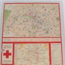
Map - American Red Cross Clubs, Paris, France
American Red Cross Map of Paris showing locations of American Red Cross Clubs, map of the Paris-Metro lines, Listing of public buildings and places to see, instructions for asking your way and general information. Reverse side is part of a special 1941 edition grid map (leaf number 243) of the area around Logrono, Spain, with explanation of symbols in both German and Spanish. An American Red Cross button with a red cross and the words "I Gave" ...
Record Type: Archive
-
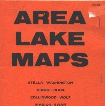
Map - Area Lakes
Booklet of McLeod County area lake maps for Stella, Washington, Jennie, Hook, Collinwood, Wolf, Marion, Swan, Manuella, Big Swan. Also McLeod County and Meeker County maps. Published by Quade's Sporting Goods, Hutchinson MN. Undated. $3.95. A complete list of products and supplies available at Quade's Sporting Goods is inside the cover. "Everything for the Sportsman".
Record Type: Archive
-
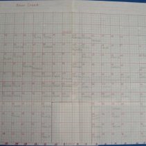
Map - Bear Creek Cemetery, Rich Valley Township, McLeod County
Map of Bear Creek Cemetery, Rich Valley Township, McLeod County. Original is on graph paper. Also several photocopy enlargements.
Record Type: Archive
-
Map - Biscay, MN
Map of Biscay, MN, c.1951. Shows blocks, lots, streets, location of public buildings, section center, Chicago. Milwaukee, St. Paul & Pacific railroad tracks. SAR No. 4 is marked in blue and TH22 is marked in red with Highway Department reference number 4307. The population of Biscay was listed at 108.
Record Type: Archive
-
Map - Biscay, MN, c.1910
Map of the Village of Biscay, McLeod County, Minnesota. c. 1910 map drawn by David P. Schmitz on December 13, 1977.
Record Type: Archive

-
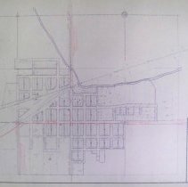
Map - Brownton, MN
Map of Brownton, MN created by M.W.P.A. Project 5259, c.1935-1943. Shows blocks, lots, streets, Chicago, Milwaukee, St. Paul Pacific Railroad tracks, location of public buildings, section corners, section center & Lake Addie. Markings show Merrill Street updated to TH 212 (212-12-F) with Highway Department reference number 4309. Original location for TH 15 and locations for CAR No. 75, CAR No. 53 & CSAH No. 102 are marked.
Record Type: Archive
-
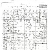
Map - Collins Township
Photocopied 1858 survey plat map of Collins Township, McLeod County. Names are on plats with dates from 1856-1881. Original land entries inserted by Grace Baleman Walton, 1986.
Record Type: Archive
-
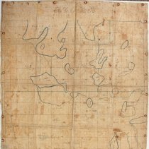
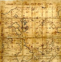
Map - Collinwood Township
Old hand drawn plat map of Collinwood Township, Meeker County, Township 118N, Range 29W. Ownership of some section acreages is written in. (Harrington-Merrill Collection)
Record Type: Archive
-
Map - Czech Brethren Presbyterian Cemetery, Silver Lake, MN
Scanned map of the Czech Brethren Presbyterian Cemetery. Drawn by R. E. M., 1980. Includes names on the plots. Scanned by halves.
Record Type: Archive